CROP HEALTH IMAGERY
Why Innovators Use Crop Health Imagery
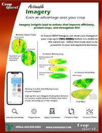
Crop Health Imagery, when viewed strictly as a “pretty picture” has been a stumbling block to producers for over a decade. However, major advancements in platforms and cameras are causing renewed interest in imagery. The time to extract value from those “pretty pictures” is here. Strengthen the return on your investments by using actionable imagery to improving efficiency and protect your crops.
Satellite Imagery
Free agriculture satellite imagery suitable for traditional crop production tasks.
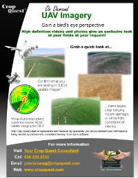
Aerial Imagery
Drone Imagery
Can Crop Imagery Save Time?
At key points throughout the growing season, you receive imagery report. Flipping through the images, you notice irrigation problems, pest damage, application skips, and recent storm damage. Some issues come as no surprise. . . Other problems stand out and you had no clue they existed. Seeing the problem and acres affected helps you decide what actions to take.
After flipping through the farm satellite imagery, you have quickly assessed the condition of each field One glance, and the images reveal decisions related to pesticide applications, nozzle packages or variable applied products. Should a new problem develop, you are alerted because the entire field is being monitored throughout the growing season.
In just a few minutes, you are able to explore every acre of your farm. You know where to target action, you know how things are progressing, and you know what to expect as harvest approaches.
Satellite, Aerial & Drone Imagery Sources
What is the Best Crop Health Imagery Provider?
The image source is not important, but knowing which image source to use to reach your goals is.
The platform used to collect the image affects the detail and timeliness of the image. We provide crop health imagery collected from all three sources at various resolutions and times. This enables us to focus attention on putting imagery to work for the producer, and allow the pilots and satellite providers to focus on what they do best – collecting images in a timely manner.
We’ve screened dozens of drone, aerial and satellite imagery providers to create an imagery network, second to none. We’ve joined forces with imagery providers that have expertise in collection, processing, and delivery of crop health imagery services. By pooling resources we’re focusing on what is important – making the image actionable.
Knowledge Base

1) Image Timing
In 2012 Crop Quest began an R&D project to explore using drones in our crop consulting services. One of the issues we hoped drones would allow us to improve on was timing.
A crop drone gives the operator flexibility in the acquisition timing. The idea of fast-food imagery, drive up to the field capture the shots and drive off, has obvious appeal. The additional control over when a crop health image is taken adds value; especially in agriculture where timing is a key element. Consider crop protection and variable rate growth regulator applications, both are time sensitive examples. Apply to early and you don’t get the residual benefits, apply to late and you risk yield loss. The improved timing a drone provides is easily recognized.
2) Image Detail
The second advantage we recognized was the image detail. A high resolution satellite image might be in the 5 foot range. An aerial image captured with a cesna might be in the 18 inch range. An image captured with a drone can be in the sub-inch range. This high resolution results in some huge file sizes that create issues of their own. However, the crop health images are stunningly detailed and we have only begun to explore how they can be implemented. An excellent example would be a whole field stand count; that may bring some value to a replant situation.
The NDVI image is valuable because it makes the differences between good and bad areas of a field or plant stand out. It relies on a wavelength (NIR) outside that measured by normal cameras or the human eye. Because of this crop stress can be detected sooner in crop health imagery. The earlier we can detect the crop stress, the better chance of protecting the crop and improving yield.
NDVI is the abbreviation for the Normalized Difference Vegetation Index, and is a calculated ratio of the reflectance of visible (VIS) and near-infrared (NIR) light.
NDVI = (NIR – VIS) / (NIR + VIS)

The higher the amount of green vegetation the higher the NDVI number. NDVI numbers range between -1 and 1. Values close to -1 represent deep water. Values close to 0 correspond with bare earth. Values closer to 1 correspond to dense healthy crops.

A field as viewed through our eyes.

The same field viewed as an NDVI.

NDVI from June 28 (left) and July 12 (right) showing variation in crop development.
A lag in corn development on the West side of this field was observed in early imagery. Upon ground truthing that area symphylans were observed and documented. The damage was consistent with other infestations found in the region.
Further investigation indicated that while the symphylans likely caused damage, nematodes may also be weakening the plants defenses.
It was known that parts of that field had stunting issues, but the imagery gave a quick concise view of the extent of the area; which was more substantial than initially estimated from the ground. The crop health image is valuable because it makes the differences between good and bad areas of a field stand out. The earlier we can detect the crop stress, the better the chance of protecting the crop and improving yield. In this case an insecticide application at planting is being considered for the following season.
In the second image the canopy is filling in and the result is difference across the field. This is consistent with the weekly observations of the crop consultant.
It’s worth noting that this field had staggered emergence due to spring weather conditions, which probably masked some of the variation across the field. The dark green area on the East side is a different variety.